

Filter by
Map Type
Export Control Classification Number (ECCN)
RoHS
Electrical Connection
Material
DFARS Specialty Metals
Housing Material
Operating System Compatibility
Maps
Multifunction Smartwatches
 | 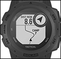 |  |
Compass | GPS Navigation | Health and Fitness Tracking |
 |  |  |
Night Vision Mode | Weather and Elevation Monitoring |
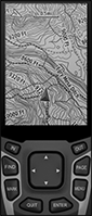
Keep your phone in your pocket and your hands free—these smartwatches perform a variety of functions on your wrist. They connect to Apple and Android phones via Bluetooth, informing you when calls, texts, and other notifications arrive. Designed for harsh environments and rugged use, they meet military standards for resistance to hot and cold temperatures, shock, splashes, and submersion in up to 100 meters of water. These watches have a compass and GPS for tasks such as navigation, tracking and saving location coordinates, and calculating the area of a location by walking the perimeter. With weather and elevation monitoring, you can set the rate of barometric pressure change that will trigger a storm alert. These watches track health and fitness metrics over time, including heart rate, blood oxygen levels, and exercise. They have a solar battery in addition to a rechargeable lithium-ion one to extend the time between plug-in charging.
Display | Housing | Band | |||||||||||||
|---|---|---|---|---|---|---|---|---|---|---|---|---|---|---|---|
Lg. | Wd. | Display Time, hr. | Temp. Range, ° F | Material | Color | Material | Color | Closure Method | Power Source | Battery Life, day | Features | Mil. Spec. | Each | ||
| 7/8" | 7/8" | 12, 24 | 0 to 140 | Fiber-Reinforced Plastic | Black | Silicone Rubber | Black | Buckle | Battery, Solar | 28 | Compass GPS Navigation Health and Fitness Tracking Night Vision Mode Weather and Elevation Monitoring | MIL-STD-810 | 5262N11 | 0000000 | |
Handheld GPS Navigators
 |  |
Digital Display |
Navigate on foot with real-time GPS data. These handheld navigators access multiple Global Navigation Satellite Systems (GNSS) for accurate positioning even in remote locations and challenging environments such as dense forests. Use them to guide yourself to your destination, track and save up to 5,000 coordinates, and calculate the area of a location by walking its perimeter. They’re preloaded with topographic maps that include terrain contours, elevations, and bodies of water. Navigators have a color display, so it’s easy to read map details. Built for outdoor use, they stand up to splashes, rain, and snow.
To receive email, text, and call notifications on these navigators, link them to your smartphone via Bluetooth. Connect them to a computer with the included USB cable to upload additional maps or offload data and files. For extra storage, insert a memory card.
Digital Display | Overall | ||||||||||||||||||||||||||||||||||||||||||||||||||||||||||||||||||||||||||||||||||||||||||||||||||
|---|---|---|---|---|---|---|---|---|---|---|---|---|---|---|---|---|---|---|---|---|---|---|---|---|---|---|---|---|---|---|---|---|---|---|---|---|---|---|---|---|---|---|---|---|---|---|---|---|---|---|---|---|---|---|---|---|---|---|---|---|---|---|---|---|---|---|---|---|---|---|---|---|---|---|---|---|---|---|---|---|---|---|---|---|---|---|---|---|---|---|---|---|---|---|---|---|---|---|---|
Image Resolution | Lg. | Ht. | Operating System Compatibility | Operating Temp. Range, ° F | Batteries Included | No. of Batteries Req. | Battery Size | Ht. | Wd. | Dp. | Enclosure Rating | Includes | Each | ||||||||||||||||||||||||||||||||||||||||||||||||||||||||||||||||||||||||||||||||||||||
Plastic Housing | |||||||||||||||||||||||||||||||||||||||||||||||||||||||||||||||||||||||||||||||||||||||||||||||||||
With Bluetooth Connectivity and Mini USB-B Connection | |||||||||||||||||||||||||||||||||||||||||||||||||||||||||||||||||||||||||||||||||||||||||||||||||||
| 160 × 240 | 1 1/2" | 2 1/4" | Android 4.2 or Later, iOS 6.0 or Later | -4 to 120 | No | 2 | AA | 6 1/4" | 2 1/2" | 1 1/2" | IP07 | Carabiner, USB Cable | 6018N111 | 0000000 | |||||||||||||||||||||||||||||||||||||||||||||||||||||||||||||||||||||||||||||||||||||
Evacuation Map Holders
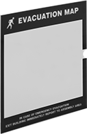 |
Identify evacuation routes at a glance. Print your evacuation map onto the included transparency film, then expose these map holders to ambient light and the holder will illuminate the sign in the dark. Insert the map from the side. Mount these holders to a flat surface with the included mounting tape.
For Max. Sign | Cover | ||||||||||||||||||||||||||||||||||||||||||||||||||||||||||||||||||||||||||||||||||||||||||||||||||
|---|---|---|---|---|---|---|---|---|---|---|---|---|---|---|---|---|---|---|---|---|---|---|---|---|---|---|---|---|---|---|---|---|---|---|---|---|---|---|---|---|---|---|---|---|---|---|---|---|---|---|---|---|---|---|---|---|---|---|---|---|---|---|---|---|---|---|---|---|---|---|---|---|---|---|---|---|---|---|---|---|---|---|---|---|---|---|---|---|---|---|---|---|---|---|---|---|---|---|---|
Ht. | Wd. | Thk. | Message Color | Ht. | Wd. | Material | Color | Material | Color | Mount Type | Includes | Each | |||||||||||||||||||||||||||||||||||||||||||||||||||||||||||||||||||||||||||||||||||||||
Evacuation Map | |||||||||||||||||||||||||||||||||||||||||||||||||||||||||||||||||||||||||||||||||||||||||||||||||||
| 8 1/2" | 11" | 0.063" | Glow-in-the-Dark Green | 11 1/2" | 12" | Polycarbonate | Black | Polycarbonate | Clear | Adhesive Back | Two Transparency Film Inserts | 2255N1 | 000000 | ||||||||||||||||||||||||||||||||||||||||||||||||||||||||||||||||||||||||||||||||||||||
| 11" | 17" | 0.063" | Glow-in-the-Dark Green | 15 1/2" | 17 1/2" | Polycarbonate | Black | Polycarbonate | Clear | Adhesive Back | Two Transparency Film Inserts | 2255N2 | 000000 | ||||||||||||||||||||||||||||||||||||||||||||||||||||||||||||||||||||||||||||||||||||||
